Event piques interest, cranes necks, and showcases advantages.
By Karen Prater (Posted October 10, 2019):
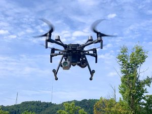
Eyes were fixed on the sky above PIkeville, KY, as our state-of-the-art drone took flight under the control of licensed pilots Andy Willis and Gabe Shepherd.
The future is here … in 2019 … in Pikeville, Kentucky.
That thought hit me as SynTerra (formerly ECSI) hosted its Drone Exhibition at Kentucky Enterprise Industrial Park. I apparently wasn’t alone in my realization. Every guest listened intently as Andy Willis and Gabe Shepherd — SynTerra’s licensed drone pilots — discussed advantages of this exciting technology. Andy and Gabe explained how drone applications save time, and they emphasized cost-efficiency. Most importantly, they explained how drones enhance safety.
And they skillfully flew SynTerra’s new state-of-the-art Matrice 210 RTK V2, made by industry-leader DJI. “Awesome” would be an understatement. It was amazing, almost impossible to look away. But I did sneak a glance at the crowd, and all eyes were fixed upward, locked in on our mechanical wonder. Pardon the hyperbole, but the flight really was enchanting.
Back to Earth. Sure, there’s the cool factor. Only a short time ago, drones were the thing of movies — devices of intrigue, or toys of the very elite. But we’ve gone beyond the novelty, and organizations like SynTerra are using drone technology to acquire more data from more places, while enhancing safety. In land surveying, the use of drones saves hours of time while making jobs easier and more cost-efficient. We now have an all-in-one tool. Instead of using theodolites, infrared reflectors, and GPS, land surveyors can now use a drone. With drones, gone are the days when it was necessary to spend countless hours surveying by foot. A drone cuts long field days short, with the same results.
SynTerra uses drones for planning and mapping, inspections, taking photos, grid work, and acquiring data from throughout a property, including rough terrain and hard-to-reach places. Drone mapping provides increased speed and automation that allow SynTerra to safely take on and complete more jobs, on more sites, in less time.
SynTerra uses drones to support project goals, enhance work products, improve results, and reduce risk while maintaining or reducing project costs. With drones, it’s easier and safer to inspect elevated structures such as rooftops and towers, confined spaces such as tanks and tunnels, and large areas such as quarries, landfills, and wastewater systems. SynTerra uses drones to collect data for survey-grade maps and 3D models that support civil engineering projects. And it all can be done in hours on-site instead of days.
We were excited and proud to have hosted the Drone Exhibition and lunch. (Many thanks to the City of Pikeville for letting us use the park.) There’ll be more of these events, for sure. It’s great to be at the forefront of technology, helping clients and potential clients discover safer, more efficient means of achieving their business objectives.
And yes, drones are cool!
Learn more about SynTerra drone capabilities.